[Northern Waterthrush in morning flight at Higbee Beach WMA, NJ Sunday morning.
Only, it's not magic at all, in fact it is relatively simple stuff to know when a good day is coming (predicting truly massive flights is less easy, but still sometimes possible.) You look at the date - early August, OK, what species are likely migrants now? (see blog below.) You look at the weather map and charts - when is a cold front going to pass through Cape May? Will the winds turn to northwest before nightfall or at least sometime in the night? Plan to go birding the morning after. And, if you want, check the weather radar before you go out to gauge the extent of migration.
[Velocity weather radar at 2:40 a.m. Sunday morning, August 8, 2016, from Dover, DE. Blue colors are birds flying towards the station, hot colors are birds flying away. Notice they avoid flying over the water; this radar image with a "bite" out of it on the east side is a great predictor for birds on the coast in fall. The blob at the bottom right is a rain squall associated with the cold front that passed.]
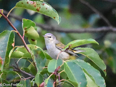
[A bit of a surprise, this male Tennessee Warbler on Sunday morning was among the earliest southbound Tennessee's ever recorded at Cape May, right in front of the concrete platform in the first field.]
As of now, the next little hit of migrants seems likely Tuesday-ish next week, but that's 8 days away, so don't hold me to it. Dribs and drabs until then. Yesterday morning I ran into about 40 individual warblers of 8 species, and heard of at least two other warbler species seen by others. Not to mention a couple dozen Eastern Kingbirds, Orchard Orioles, waxwings, etc. And the fall mosquito crop seemed not to be abroad yet, though there are still deerflies around. . .


No comments:
Post a Comment